• Skip to primary navigation
  • Skip to main content
  • Skip to primary sidebar
  • Home
  • Research
  • People
  • Contact Us
  • Publications

CAST - Connected Autonomous Safe Technologies

Texas A&M University College of Engineering

Research

Hard Platooning

What is Hard Platooning?

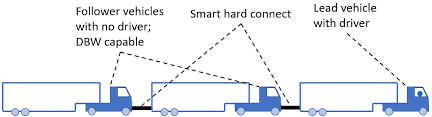
Hard Platooning is a technology that links multiple military vehicles together using a physical connection called the Hard Connect product. Unlike traditional Leader-Follower (LF) systems, where robotic vehicles follow a human-driven or remotely operated lead vehicle using wireless communication, Hard Platooning uses a physical tether. This setup allows one person to control multiple vehicles at the same time, reducing the workload for soldiers and improving coordination.

Why is Hard Platooning needed?

Hard platooning provides benefits for the U.S. Military, transit systems, and the trucking industry by making transportation safer, more reliable, and more efficient. Transit agencies, which prioritize safety around pedestrians and cyclists, struggle to adopt fully autonomous vehicles due to safety concerns. This new system uses a human-driven lead vehicle with automated followers connected by a smart physical tether, solving these worries. This technology can solve labor shortages and boost productivity, without compromising safety for the trucking industry. For the military, this technology can enhance path tracking, and expand ground vehicle capabilities. Unlike fully autonomous vehicles, this system uses the driver to bypass unpredictable obstacles, like bad weather and cybersecurity risks. The tether will transmit data between vehicles, ensuring they can follow the same path without needing changes to infrastructure.


What is CAST doing to improve Hard Platooning?

Current work involves analysis of system dynamics, development of nonlinear control strategies and full-scale experimentation on both class 8 trucks and transit buses.


David “DJ” Franklin, Michiel Ashley, Matthew Hancock

Infrastructure Enabled Autonomy

The core of any localization system is the sensor fusion unit in which its capabilities are limited by the performance of the sensors and underlying fusion algorithms. Of the different sensors, the Global Positioning System (GPS) sensor can provide information on the ground truth (GT) which can be leveraged along with other in-vehicle sensors to achieve accurate absolute localization. However, the GPS signal can be blocked by tall buildings, bridges, or tunnels in urban areas. Furthermore, the GPS is vulnerable to malicious attacks and signal spoofing. This motivates the value of a reliable absolute localization system that does not use GPS. Considering the operating areas of autonomous cars, one of the best ways to achieve such a GT is infrastructure.

Passive : In the paper, Localization in Global Positioning System–Denied Environments Using Infrastructure-Embedded Analog-Digital Information, we proposed Passive Infrastructure Localization in which the localization unit is in the car and GT is inferred from ”smart infrastructure”, using appropriate in-vehicle sensors. The ”smart infrastructure” is essentially a series of ”smart landmarks” that provides (i) digital identification information (such as can be obtained through a bar code or QR code), which can be read with very low uncertainty, and (ii) analog information about the landmark (such as the GT and geometric parameters of the landmark), which is obtained by cross-referencing the digital identification of the landmark to a database (which can be either stored on-board the vehicles, or made available on the cloud using relatively low-bandwidth services). Sensors are tailored to be able to read not only the digital information of the landmark, but also perform relative localization of the ego-vehicle with respect to the landmarks, leveraging the analog information extracted on the landmark.

Active: The term ”Active” implies that infrastructure itself is actively taking part in localization instead of just providing GT. In this method the localization task for all vehicles on the road is fully conducted by infrastructure itself and fused information is transferred to vehicle via wireless communication. The advantage of this method is that it can offload some of the computational weight from the ego-vehicle and provide a centralized localization unit. Here the GT information is already available in the infrastructure from the location of sensing equipment. Since the sensors are stationary, their exact location combined with their output estimation can provide us with the absolute localization.

Multi Target Tracking

Target tracking is a common task for robotics, which involves perception, inference and planning. We investigated algorithms in MTT in both single sensor system and multi sensor system, aiming to achieve robustness and resilience in detection.

https://github.com/TianqiLi7398/EcoDriving_Intersection

Tianqi Li

Reshaping Local Path Planner

https://akshaysarvesh25.github.io/ReshapingLocalPathPlanner/

Semantic Mapping for Off-Terrain Autonomous Robots

What is Semantic Mapping in the context of autonomous robots?

Semantic mapping, in the context of autonomous vehicles/robots, involves creating a representation of the world or environment so vehicles can understand the meaning of different objects that are present. This is done using labels which can characterize certain objects – an example of this would be a robot identifying a sidewalk as an area it is prohibited from, and asphalt as a material it is able to drive on.

The current state of the technology does not capture a robot’s surroundings to a sufficient degree. A majority of the datasets used to identify objects are integrated into the program, which means new information requires complete rewriting of the code. Complicated terrains require more research – in order to fully implement semantic mapping into autonomous robots, the technology must be able to understand relationships between multiple domains. These domains may include terrain, weather, and other factors.

Why is Semantic Mapping needed?

For unconventional scenarios, robots must be implemented with a better understanding of their different observations. Specifically, off-road situations demand unique understandings of both the robot’s surroundings, and the robot’s fleet’s surroundings to string together a sufficient model of the environment.

The first application for this technology is disaster response – if the robot is autonomously and semantically able to identify that it is going through a natural disaster(earthquake, tsunami, etc.), it will be able to assist society in minimizing the damage. Similarly, semantic mapping used in search and rescue robots will greatly maximize the chance of success, while minimizing the risk involving the human rescuers.

Finally, semantic mapping may be used for military applications. Reconnaissance missions will have the capabilities of being fully autonomous, maximizing our use of military resources.

What is CAST doing to improve Semantic Mapping?

CAST uses conventional artificial intelligence based approaches, including description logics to model the entire environment. By implementing artificial intelligence into these robots, it is possible for them to make knowledgeable inferences based on rules defined in the code about their environment. CAST is also presenting how our methods of semantic mapping can be better leveraged for various applications including decision making and fleet management.

Anant Bhamri

Archived Projects

Eco-driving in urban area :
A eco driving style (motion planning) is studied in this project for the pursuit of fuel economy and safety. Specifically, an efficient searching algorithm in state space is proposed for the optimal motion planning of a single vehicle traversing a signalized intersection. This deterministic algorithm is extended to a stochastic scenario, where the vehicle only has partial information of the traffic light. Here a Markov Decision Process (MDP) based model is used to help reduce the fuel cost for traversing the intersection.

High Efficiency Electric Vehicle Powertrain :
“Range anxiety” continues to be a major hurdle to large scale adoption of electric vehicles, and this project attempts to address that with an unconventional powertrain architecture. In this project we propose an architecture inspired by Electronic Continuously Variable Transmissions (E-CVTs) used successfully in hybrid electric  vehicles. The E-CVTs employ Motor-Generator Units (MGUs) and Planetary Gear Trains (PGTs), and pose a controls and optimization problem to balance the ability to deliver the right speed ratio at maximum efficiency, and that is the focus of this project.

Safe Core Architecture : –To be updated–

Virtual Autonomous Driving Simulator : –To be updated–

Health Monitoring for Cyber Physical Systems : –To be updated–

Dynamic Watermarking for Cyber Security in Autonomous Vehicles : –To be updated–

Formalization of Human-AV  communication : –To be updated–

Auto-Pedestrian : –To be updated–

Vehicle Driving Simulator : –To be updated–

Reconfigurable Autonomous Driving Test Environment : –To be updated–

© 2016–2025 CAST - Connected Autonomous Safe Technologies Log in

Texas A&M Engineering Experiment Station Logo
  • College of Engineering
  • Facebook
  • Twitter
  • State of Texas
  • Open Records
  • Risk, Fraud & Misconduct Hotline
  • Statewide Search
  • Site Links & Policies
  • Accommodations
  • Environmental Health, Safety & Security
  • Employment